Thanks to Elspeth Hilton Kim, Center for Natural Lands Management, for submitting this post.
Information sharing is key to controlling the spread of invasives
Invasive plants alter habitat structure and function, often reducing diversity and competing with or reducing habitat suitability for native plants and animals. Control of invasive weeds is critical to restoration of natural habitats and recovery of rare and listed species. As climate change and other factors create opportunities for the spread and introduction of new invasive species to make inroads on prairie and oak habitat in the Willamette Valley-Puget Trough-Georgia Basin (WPG) ecoregion, it’s critical that we share information across sites to identify trends and share lessons learned. To do this, the Center for Natural Lands Management (CNLM) set out to identify the distribution of ten invasive species that are thought to be emerging issues in the ecoregion. The goal is to better control present weeds and prevent the establishment of new ones.
Through discussion with prairie and oak habitat land managers in the WPG ecoregion, ten invasive species were identified as growing threats: Amur honeysuckle (Lonicera maackii), salad burnet (Sanguisorba minor), meadow foxtail (Alopecurus pratensis), lesser celandine (Ranunculus ficaria), Japanese hedgeparsley (Torilis japonica), European blackberry (Rubus vestitus), sterile brome (Bromus sterilis), Long-stalked cranesbill (Geranium columbinum), rat tail fescue (Vulpia myuros), and burrowing clover (Trifolium subterraneum).
CNLM conducted outreach to land managers throughout the Cascadia region to better understand the occurrence and response to these ten species. The survey asked respondents to describe the occurrence of these species on a site by site basis – including the species’ current prevalence, and what, if anything, site managers are doing to control the species and to what degree of success. Data was provided for 21 sites so far, giving an indication of the distribution and response level to these species. With more data, we will be able to get a better picture of the state of these invasives and where resources should be directed, including the development of management guidelines.
Maps provide additional insights into weed distribution
We created maps with the initial data, and the additional information such as treatment levels and success give us a more nuanced understanding. For example, Amur honeysuckle was not reported as ‘known to occur’ at any sites surveyed, though it is known to be spreading through the Pacific Northwest. This was one of a few species that many respondents were not aware of and felt they couldn’t identify in the field – suggesting more information about this species would be beneficial in preventing its spread.
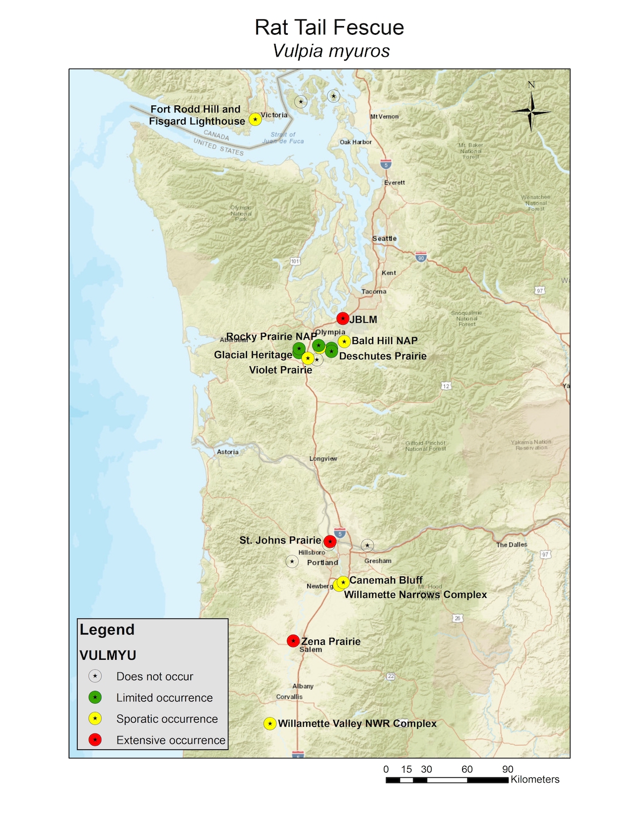
Another example is rat tail fescue. Results for this species show occurrence throughout the WPG ecoregion, yet poor treatment success was reported, suggesting new methods of control of this pervasive species are needed.

With this in mind, CNLM has created management guides with what information we do have for eight of the ten species, which can be found on the CPOP technical library.
Participate in the Survey
While this first round of data gave us some good insights, we know we’ve just scratched the surface. We’re looking for more responses and are putting out a special call for British Columbia sites, as we only have data for one at this point. The survey takes 15-30 minutes to complete (depending on your number of sites). Please help us document where and to what level these species occur on your site(s) by completing either form of the survey and submitting GIS shape files of your species occurrence boundary maps. We will update the maps with more data and put out a summary paper with the results.
